Dragontail & Colchuck 6.16.12
In keeping with the June 2012 trend, the weather forecasts were looking terrible for the weekend. Sara and I had Black Peak on the calendar. Wednesday the weather there was looking half way decent for Saturday so we made a couple plans - one to do it in a day or one to climb it on Saturday, but camp Sunday and hike out then in the possible rain. Of course every six hours or so the weather forecast would do a 180 and be completely different. Thursday morning the forecasts showed 70% chance of rain at Black all weekend so we scoured the map in NOAA looking for something more promising. The Colchuck area was looking pretty good so we decided to head there instead. By lunch on Thursday we had a new plan to tag Dragontail and Colchuck, or just one depending on how we felt on the climb. Before getting out of bed on Friday I checked the weather forecast and it was more dismal, 30% chance of rain starting at 11AM. Sara and I still decided to give it a go, and thought maybe we should start earlier to beat as much of the rain as possible. The second alpine outing for ICC was also that weekend, which had Aaron and Matt instructing together on Shuksan. Their forecast was even more dismal than the one for Black Peak so everyone ended up targeting something near Colchuck. They were going to camp for the weekend and crag on Sunday, so Sara and I decided to join them. It would beat sleeping at the trailhead in the car - or so we thought.
Sara and I were planning to start earlier in the morning so we wanted to get going sooner after work on Friday so we could go to bed earlier. We left Seattle with the plan to find a campsite, first trying Eightmile and then Johnny Creek. The boys would come later and find Sara's car and join us. We had the two tents including all of Matt's sleeping system. We stopped at the Old School Bus BBQ along Highway 2 on the way out for some delicious dinner, getting there right as they were closing up for the night about 7PM. We rolled into Leavenworth sometime after 9PM and started searching for a campsite. The sign outside Eightmile said it was full but we checked just in case - it really was full. Then we went to lower and upper Johnny Creek - full as well. Apparently the weather drove everyone to Leavenworth for the weekend. Keeping in mind we had essential gear the boys needed for sleeping, we decided to pull off alongside the road so they would spot the car. We drove past Bridge Creek and the road up to the Lake Stuart trailhead, and settled on the large turnout by Classic Crack. We quickly got ready for bed and with about 5.5 hours before our wake up time at 4AM, Sara settled into the backseat in her nest of down while I reclined in the passenger seat to get a few hours of sleep before our epic adventure the next day.
We assumed the boys would find us during the night but after waking up once at 2AM, I figured otherwise. I snoozed the 4AM alarm a couple times and finally we were up at 4:15AM, on the road by 4:30AM to head up the gravel forest road to the trail head. We arrived and geared up, leading Sara to the realization that she had forgotten her gaiters - shoot. I clearly wasn't thinking and forgot to offer her the duct tape I had thrown in my duffel, and of course I didn't put it in my backpack to bring with us even though I normally do. Luckily Sara wasn't deterred by the missing piece of gear, and after signing the permit, we were on the trail at 5AM. Sara was getting her GPS turned on so I started off on the trail since I'm generally the slow one. I was pushing kind of hard, trying to make good time to the lake. Our tentative estimate was 3 hours to the lake, 30 minutes to get around it, another 3 hours up Asgard Pass, 2 hrs to the summit of Dragontail, another 1.5 down to the Col, 2 hours to summit Colchuck and get back to the col, followed by an 1.5 hours to the lake and 3 hours back to the trailhead. Total estimate of about 16/17 hours depending on how everything went. We were expecting rain and not knowing how I would be doing (thanks to an awesome cold that filled my lungs with crap) we were approaching the day with some flexibility, leaving open the option of turning around when we wanted. However, neither of us back down very easily and I was planning to make it nearly impossible for Sara to say no to summiting Colchuck by putting it within a mere 700' of us from the col - I mean what's another 2/2.5 hours on top of a 13 hour day already? We'd have done most of the hard work by then anyways. Sara has also learned that I do a lot of stupid things while sick that generally don't end well (Silver Star, Ingalls, trying to climb two Washington Top 100 peaks in a day…) but she's a good sport and humors me. It's with this optimism (cynicism) that we approach all of our climbs.
After charging up the trail for a while, I was a bit light headed and needed to stop for some Gu. It was pretty warm out as well so we delayered a bit and decided it would be a good idea to fill up a water bottle at the lake when we got there. Luckily I had stuck in my iodine tablets just in case.

Sara crossing a bridge on our way to Colchuck Lake. This bridge was just after the fork in the trail to the two lakes
Sara took over lead and we were soon at the trail junction. I had hiked into Lake Stuart the prior October so I was familiar with the trail up to this point. We crossed a bridge, made our way across some boulders, and started up the dirt trail to the lake. We kept up a pretty steady pace and were at the Lake in about 2 hours - not bad!
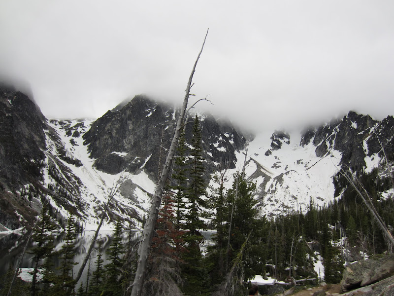
Asgard Pass, Dragontail, Colchuck Glacier, and Colchuck in the cloud
We soon came across a couple of guys sitting alongside the trail. They had planned to do Backbone on Dragontail but the route appeared to have snow, and unfortunately they didn't bring their ice axes so they were trying to figure out a backup plan since they were at the lake at 7AM and had a whole day. We continued up the trail a little to a point that had easy access down to the lake. I filled my water bottle, read the directions for the iodine tablets since I had never used them, and stuck a couple in. We continued to make our way across the lake, following the trail or boot path, since we were finally encountering more snow. Finally we cleared the trees and had a good view of the Colchuck Glacier and Asgard Pass. There was a group of four heading up the glacier and we spotted a sweet glissade track down. Our plan was to go up Asgard Pass but down the Colchuck Glacier so we noted to head left when we hit the moraine on our way down to find the glissade chute.

Looking up towards Colchuck. We saw the awesome glissade chute so we knew where to aim on the way down. Also saw a group of four heading up - a few early starters besides ourselves
The sun was almost trying to poke out of the clouds, so we stopped to put some sunscreen on and get sunglasses out. We were going to wait until we got closer to Asgard Pass to pull out our ice axes and helmets. During our break a big goat found us and followed along the trail for a bit before finally disappearing.

This goat followed us for a while as we made our way to the base of Asgard Pass
There was a slight boot pack we were following but the steps were partially filled in with snow so we were half way kicking steps for ourselves. The snow was fairly soft/slushy so we could get pretty good purchase with our boots. Sometimes we'd find a harder spot and just kick in our toes, but we decided we wouldn't need the crampons. We stopped by a pile of rocks and grabbed our helmets and ice axes. Sara took lead back and started up Asgard Pass. We could see the dirty snow from some rock fall and some of the running water. Our objective was to avoid both hazards as best as possible. We were heading up the pass about 8AM following the faint boot pack still, climbers right up the pass. Unfortunately it did not freeze the night before so everything was a bit soft and there were a number of rocks shooting off Dragontail, out of one couloir in particular. We started trying to angle more climbers left to put some distance between ourselves and Dragontail as a smaller rock came flying down and missed me by about a foot as I moved my leg out of the way. We kept going up and soon a large rock/small boulder was shooting down towards us. We started hustling up but as it was making its way towards us I stopped and the rock split the two of us, obliterating the steps Sara had just kicked. That was a bit too close for comfort, it definitely would have taken one of us out.

You can see the path the large rock left between us, obliterating the steps
We continued up past the rock fall area, nearing the top of the pass. The river running underneath was getting louder and we soon made our way onto the rocks to seek solid ground underfoot. We could see ice and a hole through the snow to the river below and didn't want any part of it.

Trying to avoid a massive river under the snow, you can see the ice up ahead and the hole in the snow

First blue skies of the day with what looked like some sun in the distance, beyond Colchuck Lake below. Still a little bit of ice on the lake
We scrambled up the rocks, seeming to have found the trail, and followed the boot tracks across the snow. Finally we were at the top of Asgard Pass. Unfortunately the clouds had rolled in so we checked the GPSs and map to get an idea of where we were going. I had waypoints on my GPS, Sara had a topo map on hers, and I grabbed out my actual map so we could discuss where we were headed. I knew we had to traverse below the ridgeline and over to the summit. There was a boot pack heading from the top of the pass into the bowl, but not wanting to lose elevation, we stayed high and traversed. I took lead to give Sara a break and kicked steps. The clouds broke just enough that we could see where the other boot path went and knew we were aiming for the saddle ahead.

We had to traverse over and up to this saddle. We were shooting to head up just left of the rocks on the right
We made steady progress and were soon at the saddle. I needed a break which meant I got to clear my lungs a bit with another coughing fit.

Clouds lifted just a little during our quick break at the saddle to get a good view of where we just came from
The wind had picked up so I threw my jacket back on and we rounded the corner, finally the summit was in sight. We had about 200' of rocky/sandy benches left.

200' to the summit
We started heading up towards what we thought was the summit, making our way up and over the rocks. When we got to the rock, we checked out a crack and half thought about climbing it to get on the summit. We weren't sure about downclimbing it though so we elected to walk further along the ridge. Sara looking over felt like we were actually now heading towards the true summit as it was higher than the rock we had just been looking at. We got a couple summit shots with the wonderful clouded in view.

Sara and I on the summit of Dragontail
I finally successfully summitted my first Washington Top 100 peak - #26, Dragontail at 8,840'. Sara checked her third off the list (having bagged #2 and #3 already). We headed back down a bit to a less windy spot for lunch. . We both had our sandwiches - Sara had her huge 6” sub from subway - and a summit treat pixie stick.
Our next objective was finding our way over to Pandora's Box and making our way down through that to reach the col. This was the part of the trip that I was most nervous about as I didn't really know what to expect. I had read reports about cornices and others about people roping up to climb gullies. We had our crampons, ice axes, and helmets and that was it, although Aaron told me we didn't need a rope based on his trip last year with Matt doing the same route. Sara started the traverse over. I felt the worst throughout that entire day on the traverse, for whatever reason, so it was nice to just mindlessly get to follow Sara across. We passed a couple guys coming up from the col who said there was a nice boot pack the entire way so that made us feel better. We stuck close to the ridge, mostly following the boot pack and trying not to lose too much elevation. I knew if we stuck to the ridge we'd get to Pandora's Box too. We came to a steep section of snow and rock, what I mistakenly thought was Pandora's Box based on my memory of what I had seen in trip reports. There were two sets of steps up so we took the right side up and over the rocks, and found more of a traverse before us.

Sara leading the traverse along the ridge on our way to Pandora's Box
As we approached the next section of rocks we found a team coming up the gully. I spotted the balancing rock as well and recognized this as Pandora's Box. We walked over on the rocks and checked things out.

Found Pandora's Box, now to figure out how we get down the other side
There was a steep snow slope up to a flake or knife edge of snow, or the gully the group was prusiking up. We decided to wait for the group to finish getting the last of their members up and then we'd head down. The group warned us that there were a couple class 4 moves and loose rocks. Sara started down as I was still feeling a little light headed (promising to catch me if I fell - ha).

Sara heading down the rock gully at Pandora's Box
The first half of the gully was pretty easy downclimbing, but then we got to a spicier section. There was a drop off of more than 6 feet to the snow directly below us. There was a crack to our left but that didn't seem like a good idea. There was also a corner to our right that we had to traverse an exposed slab section to get to. After looking the options over and trying to see where the steps in the snow went, Sara decided to take the couple steps across the slab section and get herself into the corner. She had one bomber hand hold on the left and slowly worked her feet out onto the slab that had the slightest little seam across it, as she tried to reach the crack on the right. She got over there and found a great hand jam and one good foot hold. Unfortunately the next step was working the rest of her body down onto the foot hold to reach the corner.
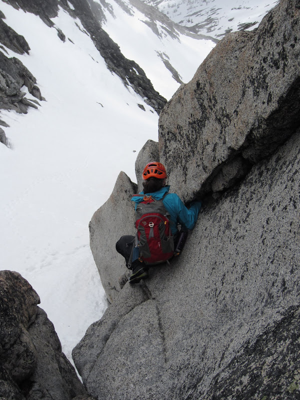
Sara trying to work her way down into the corner to reach the snow below
As she slid down towards it, she also slid a bunch of skin off her hand. Not feeling great about the position she was now in, she backed off and decided to climb back up to try and find a different way down. She made it back across the slabby portion and back to the bomber hand hold, from there she easily came back up by me. I checked around the area more and figured our best bet would be to try the snow - that thin flake. At least there was no cornice. We climbed back up the gully and took a right to get out by the snow. We were already close to the top so at least we wouldn't have to go far before getting over the edge, but the snow looked sketchy. From my perspective things seemed to go pretty easily as Sara kicked steps across, knocking a bit of snow off the edge before stepping over. From her perspective she was waiting for each step to blow out and send her down the snow.

Sara kicked steps over the knife edge ridge of snow at Pandora's Box
All I know is that I had a bomber set of steps to follow across and was soon on my way down towards the col. We looked at the gully on the way down and noticed another one to the right (as we were coming down) seemed better, although I didn't remember seeing any easy way over there.

Sara heading down from Pandora's Box to the col
We made quick time down the snow slope as a few windows in the sky passed by, showing us some blue sky and a view of our next objective - Colchuck.

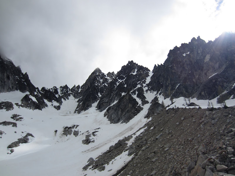
Route up Colchuck
Sara picked a trail across the rocks instead of going all the way to the bottom of them and up a little to the col. There was a group coming down and going up Colchuck when we arrived. The route seemed pretty straightforward, especially since there was a well established boot pack. There really wasn't any debate at that moment whether we were going to go up or not. We figured 2, 2.5 hrs top for the side trip to bag another summit and with less than a 3 minute break for me to clear my lungs a bit, we were off. We started up the first rock band, and then onto the snow. There was a myriad of steps so we each chose a set, trying to find some up steps instead of the large down ones. We came up to another rocky area at the top of the steep stuff with about 200' left to the summit. We crossed the last bit of fairly level snow and started up the last area of rock and dirt benches. The group of four we had seen earlier had just scrambled up the summit block. We dropped our packs and Sara enjoyed her second summit treat of the day, a Milky Way bar. Ready to head back, we did the short scramble up to the already crowded summit. One of the guys was nice enough to take a quick picture of us - again mostly of rock and clouds, and we each went and stood on the highest point so we could check #33 - Colchuck at 8,705' off our list as well.

Sara and I on the summit of Colchuck

Colchuck Lake below
I could just make out both lakes below - Stuart and Colchuck. We scrambled back down and after at most 10 minutes near or on the summit, we had started down.

Sara coming down from the summit of Colchuck
We found some new tracks to follow back across and had to do a bit of route finding through the rocky area to find the snow steps again. Of course the weather rolled in again and seemed like it was intent on raining. After a bit of annoying mist it went away though. We were down at the col 1.5 hrs after we had started up for Colchuck - much less time than we expected.

Heading down the Colchuck glacier, ready to get back to the car after a long day of climbing
Sara started charging down the Colchuck Glacier, ready to head back to the car. It had been 11 hours since we started on the trail that morning. The rock on the side of Dragontail looked really cool. It seemed the weather was clearing up - of course, when we had finished summitting all of the mountains and were heading back, that's when the views decide to come out. After a bit of plunge stepping down Sara decided it was time to glissade. I watched her go for a while, losing her water bottle, and then decided to start myself. I made my own track as I went, keeping my speed under control, and picked up the orphaned water bottle. We made it down to the moraine and headed left in the direction of the glissade chute we had seen that morning.
Looking up at Colchuck from the moraine, glacier on the far left with the North Buttress Couloir just up ahead on the right side of the picture
Another awesome glissade put us at the lake just a little over 30 minutes from leaving the col. The only thing standing between us and the car was about 4.5 miles of trail.

Sara happy to be in dry socks, but not looking forward to putting her soaking boots back on, or the 4.5 mile hike out on the never ending trail
We stopped so Sara could put some dry socks on. She was a trooper all day without her gaiters and the water she was wringing out of her boots was proof. I cleared out more from my lungs and we were on the trail. I figured we might be able to make it back to the car by 7PM, it seemed like a good target to me. The wind had really picked up and there were actually white caps on the lake as we made our way around it. For that I was glad to be back in the trees and heading home. We started heading down at a brisk pace, ready to be done with our epic adventure of the day. I know Sara likes to run down mountains so I was trying hard not to slow her down. We passed several groups hiking in towards the lake still, one full of familiar faces. We saw Robin, Lindsey, Bill, and another ICC instructor on their way in. They had climbed stump route that day and were planning on camping at the lake to do the North Buttress Couloir on Colchuck the next day. They told us we were about an hour or so behind the guys - good news! They also said the guys were planning to head to classic crack so at least we'd have an idea of how to find them.
The rain was starting again so I put my rain jacket back on - while hiking the whole time, no time to stop. We finally made it back to the junction in the trail and knew we had somewhere around 2 - 2.5 miles left to the trailhead. I had somehow blocked the first 20 minutes or so of the hike from my memory so it just seemed like it never ended. According to the GPS, we apparently got faster the longer we had to hike. Finally I saw cars through the trees and we emerged - and much to my surprise I saw Aaron's jeep in the parking lot. The guys quickly emerged and came over to greet us and tell us about their day. They got a late start and had been turned around on the North Buttress of Colchuck by a bergschrund. They had talked to some people in the parking lot that had seen us (they remembered my helmet - I did get a lot of comments on Sprinkles throughout the day), and told them we were probably an hour and a half behind them. The guys were nice and drank a few beers in the parking lot as they waited for us to get down, although Matt had left quite the note on Sara's car so we could find them. We changed into our happy, dry cotton clothing and headed into town. The guys wanted to go to the Duck and Drake for some food and beer. Not knowing if we'd find any campsites, everyone decided to head back to Seattle that night. After a long car ride of entirely too much random talking from myself to keep Sara awake, I was finally getting into bed at 12:30AM. Nothing like a 20.5 hour day, with 14 of those including climbing two mountains! Not a record setting time but a good pace for us. I had a great day - I was feeling good (despite the chest cold), we bagged two Washington Top 100 peaks, and we covered a lot of elevation and ground. A successful day, despite bleak weather forecasts!
Approximate Timeline:
- Trailhead - Colchuck Lake: 2 hrs
- Colchuck Lake - Top of Asgard Pass: 4 hrs
- Top of Asgard Pass - Dragontail Summit: 1.5 hrs
- Lunch: 30 mins
- Dragontail Summit - Pandora's Box: 1 hr
- Pandora's Box - Col: 30 mins
- Col - Colchuck Summit: 1 hr
- Colchuck Summit - Col: 30 mins
- Col - Colchuck Lake: 30 mins
- Colchuck Lake - Trailhead: 2.5 hrs
View Larger Map

Hike to Colchuck lake, up Dragontail, over to Colchuck, and back

We went up Asgard Pass to Dragontail, down through Pandora's Box to the col, up to Colchuck, and back down the Colchuck Glacier to the lake

Traverse up and over to the summit of Dragontail from the top of Asgard Pass

Traverse along the ridgeline to Pandora's Box from the summit

Down through Pandora's Box to the Col and up 700' to the summit of Colchuck