Gothic Basin 12.3 - 12.4.11
I had made it another year and wanted to celebrate. At first we considered a roadtrip down the Oregon coast, but after I saw the forecast, I just couldn’t miss a sunny weekend in the mountains. Aaron and I considered the Tatoosh and Commonwealth Basin, but then I decided I wanted to try something different. We looked at Boston Basin but the road was closed a couple miles from the trailhead. Finally we looked at Gothic Basin and decided that would be a great area. The plan was to leave Saturday morning, set up camp at Foggy Lake, and summit Gothic Peak. Depending on conditions, we’d wake up Sunday and try to summit Del Campo or just pack up and head home. It was going to be cold so our warm sleeping bags, big puffies, and down booties were packed. Aaron was bringing his new 4 season tent to try out. Not knowing what to expect on the summit attempts and if we’d encounter rock on the scrambles, we had a small rope, half set of nuts with some slings, and our harnesses with the typical ATC and rescue biner of goodies. For snow travel we had our trekking poles, ice axes, crampons, and snow shoes. Then add in the rest of the normal camping fare, plus a couple birthday hats, birthday cupcake, and cards to entertain ourselves for the night. After all of that we decided on our big packs – without a doubt the heaviest pack I’ve ever tried lugging up a mountain.
We left Seattle just after 6AM and were geared up and ready to go about 8/8:30AM from the little parking lot at Barlow pass. Snow Pea was the only car parked there. We walked to the side of the gate and started down the old Monte Cristo road which has been closed and has numerous signs warning against any vehicles using it.

First mile+ is along the old Monte Cristo road that is now closed to vehicular traffic with several signs along the way with warnings
The road was relatively flat and there was a good boot pack so no snowshoes needed. We reached what looked like a trailhead. From the descriptions I understood there to be a register and a large board for Weden creek which we didn’t see. My GPS said 0.75 miles and we were supposed to find the trailhead around a mile. After some debate we took the trail off of the road, soon realizing it was just a bypass from the road.

Seemed like a trailhead but wasn't the one we were looking for. It was actually a little bypass trail that ran just above the road - we took it on the way in but stuck to the road on the way out.
The trail was short and we got some decent views so not all was lost. Shortly after rejoining the road we found the actual trailhead – privy closed due to vandalism. There were no registration forms and after getting a quick break, we hit the trail.
The trail led us up, finally gaining some elevation, through the old growth forest. The trail had a decent boot pack and was even melted out in sections exposing the rocky trail under foot. It was slow going. We started just under 2400’ and had to make it to 5200’ to reach the lake. My cold was not making the trek easy - luckily I had brought a couple packs of tissues with me. We finally emerged from the trees to some spectacular mountain views.
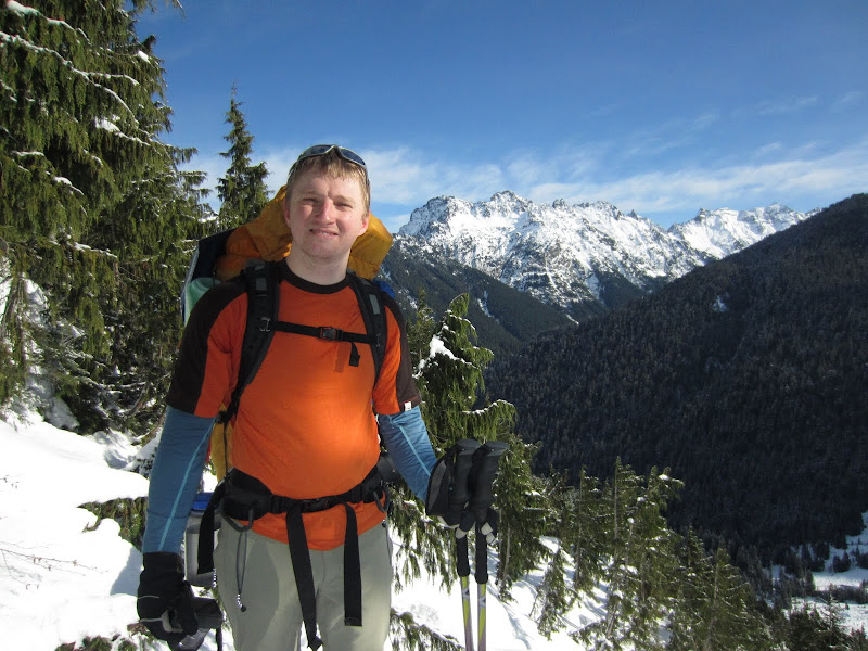
Aaron and mountains

One last panorama for the day - my favorite
It was definitely a beautiful area to be traveling through. Soon after we came across the large creek crossings. We had been following a boot pack and continued to do so – unfortunately. Looking back at our track compared with the trail descriptions I had found, I think we needed to go up higher and cross above the waterfalls.

One of the waterfalls feeding a creek running underfoot beneath the snow
We had four crossings to make – that is 4 down and ups each. We decided it was time to pull out our ice axes and Aaron started leading across, picking between the steps already there and finding new routes that seemed less ridiculous. The crossings took us a long time and I think we were both a bit drained afterwards.
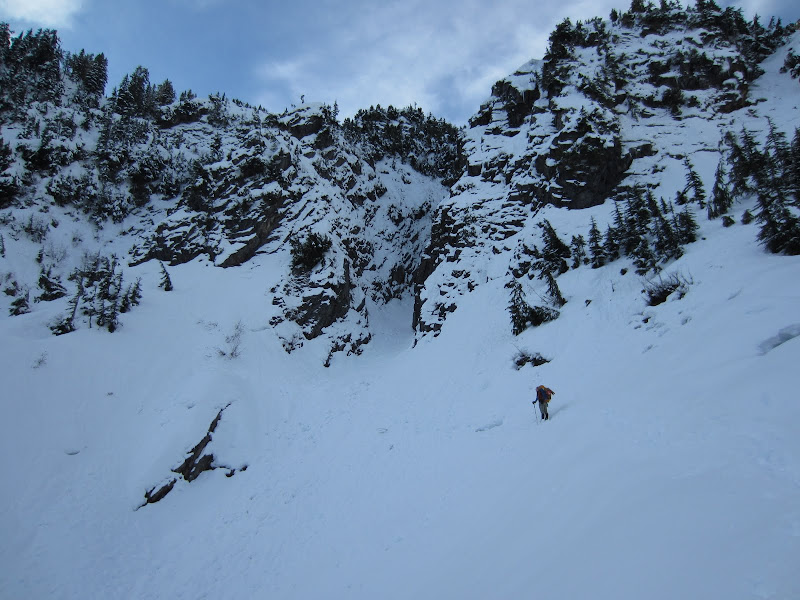
Aaron navigating us through the crossings - down and up the ridges, over the snow covered creeks

Another waterfall we passed by
After the crossings we found a snowshoe track and started up that. We were really gaining elevation now and I was falling behind, using my rest step well. Aaron had gone on ahead and did some scouting. He came back and found me and carried my pack up the last bit to where he dropped his. When I started up without the pack, I literally felt like I was floating up the mountainside. We ran out of steps to follow and decided which route to take to start picking our way across the mountain, hopefully getting closer to the lake. I kicked a few steps and then Aaron took over again, breaking a lot of new trail up and over ridges.

Aaron's steps he kicked - he was a machine heading over the ridges toward Del Campo
I was cold, tired, and not feeling the best and had had enough. Finally Aaron reappeared over a ridge and I told him I was done for the day and wanted to set up camp. We found a flat spot downhill from us a bit and set to work. Within a few minutes we had a platform cleared for our tent and the tent up. After throwing all of our gear for the night in the tent, Aaron hung our packs in a nearby tree and he suggested we take a nap. It was about 4pm so a little early for dinner and a nap in my sleeping bag sounded wonderful.

The new tent is up and the new giant puffy is on - life is good
After about an hour nap we woke up and decided to start dinner. I sat in the doorway, melting snow and boiling water to add to our Mountain House meals. Aaron hung our headlamps so we had light.

Enjoying our Mountain House dinners in the tent by headlamp
I had brought birthday hats and Aaron has carried up a cupcake for post dinner birthday celebration. I also brought up a small deck of cards to play some cribbage as we figured we’d have a couple hours in the tent to entertain ourselves before retiring for a still early bed time. A little ways into my dinner I wasn’t feeling so great. I knew I hadn’t eaten much that day and forced down a few more bites. Soon I felt really sick and had shivers starting in my legs. I decided the best course of action was to go back to sleep and hope I was feeling better in the morning.
I woke up to Aaron urging me to see sunrise. That was one of the things I was most looking forward to on the trip, a sunset and sunrise in the mountains. I sat up to look out the little tent window and immediately laid back down – still not feeling great.
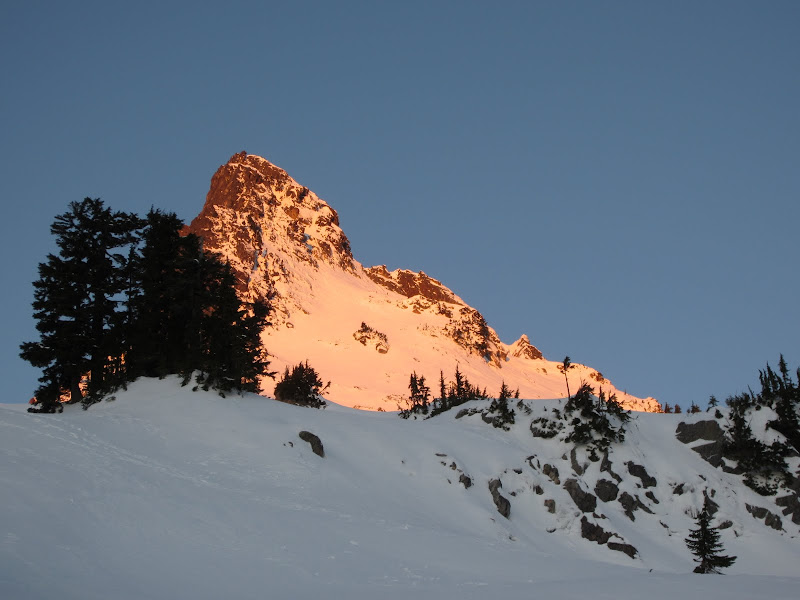
Morning sunrise alpen glow on Del Campo

Sunrise over the mountains
Obviously Sunday would be about getting back to the car, not summiting anything or even making it to the lake. Aaron took all of the heavy gear – the rock gear, stove/pot/fuel, and all tent components. I took his sleeping bag and he got everything packed up. We started down slowly, luckily the snow was nice for plunge stepping. We soon reached the four crossings again and we knew this would be our biggest challenge of the day. We decided to follow our steps back since we knew they’d get us on the right trail, instead of trying to find an easier way across. We made it to the other side, back to our nice view spot, and took a well deserved break.

The panorama Aaron got for me - one last view of the pretty mountains before heading back into the trees
We put away the ice axes and pulled out the trekking poles for the long hike back to the car – luckily all on trail. Finally we made it to the trailhead with a mile separating us from the car. After coming around a bend I spotted the gate at the end of the road and got excited – we were almost there. We arrived back at the car, Aaron happy to dump his extra heavy load, and we packed up. We had not seen anyone the whole weekend but as we were about to leave, another 5 cars showed up in the little parking area. There were several more groups along the Mountain Loop highway between hiking (Mount Dickerman) and finding Christmas trees. Thanks to Aaron we made it back, and even though the trip got cut short because I wasn’t feeling great, I still had a lot of fun. Gothic Basin is now on my to-do list to tag the summits and enjoy more great views at the lake.
View Gothic Basin 12.3 - 12.4.11 in a larger map

Area we hiked in

Our trail
The major crossings and the end of our hike up - not quite to Foggy Lake

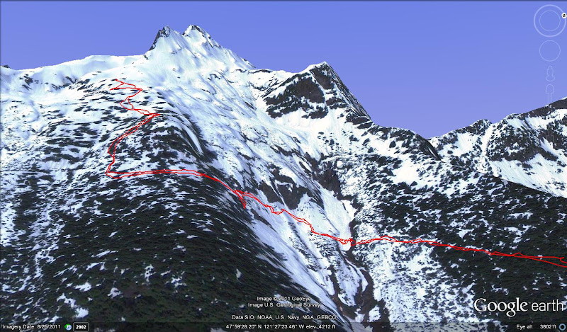
Our actual trail in red compared to our beta in blue. The possible summits in green and lighter red to Gothic Peak and Del Campo respectably Gothic Basin and its peaks just goes on my to-do list now