Mt Pilchuck 10.17.10
The weekend forecast was amazing for mid October so I decided to do a hike Sunday after my day of ice climbing at Mt Baker. I wasn't sure how I'd be feeling Sunday, but I was feeling pretty good. I've been wanting to hike up Mt Pilchuck for over a year. It felt like all of my friends had done the hike except for me and I had heard nothing but good about it. I e-mailed a few friends to see if I could gather up some company and Carla was interested. I also e-mailed an old friend from middle school and high school, Brittany, who had just moved out to the Seattle area at the end of the summer. Her and Ellie mentioned that they are not able to get out into the mountains much so I thought it'd be a perfect opportunity. I picked everyone up and we were on the road by 8AM. It was an interesting morning with heavy pockets of fog throughout Seattle. Wallingford near I-5 was horrible, but a half mile west was fine. As we drove north along I-5 we went in and out of these fog pockets, but luckily for us Mt Pilchuck was clear.
We arrived at the trailhead just after 9:30 AM. The road was in pretty good condition. There was a large section of typical gravel forest service road but it actually was pretty devoid of pot holes which was a welcomed surprise. Higher up, near the trailhead, the road was paved again - unusual to say the least. It was a bit chilly in the morning but the sun was shining so we put on sunscreen as well as our knit hats and hit the trail. The first 100 feet or so were through a large puddle/running water. Beyond that the trail was in good condition, a dirt path winding through the trees. About a mile into the hike we encountered the first talus slope and our first glimpses of the surrounding mountains. A quarter mile or so beyond that we mostly emerged from the trees and were treated with views of the North Cascades. We could see Mt Baker's snowy top as well as a faint Shuksan to the east of that. There was another huge, rocky peak mountain but I had no idea what it was. I tried racking my brain but I have not yet developed my mountain encyclopedia skills, I mostly just know the big guys.
We continued hiking along the trail, along a lot of rocks and with a lot of people. Mt Pilchuck is a popular hike and couple that with probably the last nice weekend of the year, the trail was pretty packed. I do enjoy more quiet trails but I usually deal with the crowds fine. However, there were some really chatty groups with lots of dogs. I don't mind the occasional dog on the trail or groups that are talking (that's half the fun of hiking with friends) but we were sandwiched and a specific group of ladies were loud and obnoxious. Luckily the rest of the crew saw I was starting to get agitated so we took a break to distance ourselves from the obnoxious ones. Clear of the trees we also started getting some fall colors. I had almost forgotten - fall! Last year I was hiking every weekend basically so I was in the season change, this year I haven't been out much so other than the trees out my window at work and the few I see driving around the city, I haven't noticed the season change as much. Most of the trail was in the shadow of the mountain at that time of day and there were several large patches of ice on the trail. For the most part we were able to circumvent those patches and only had a few slips from which we recovered quickly.
The trail started picking up elevation quickly and we were hiking over lots of rocks. There were numerous signs along the way to direct people to the top and to the bottom. With that many people on the trail it was good to keep everyone along one path to preserve the rest of the mountain for us to enjoy seeing from the trail. Towards the top we were hiking over rocks the entire way, with some more dirt path just shy of the summit. We finally saw the fire lookout tower and followed the sea of people up the scramble at the top. 0The scramble was actually a lot of fun. Before entering the tower,Carla and I found our way over to some rocks to take pictures of the awesome view up there. Still sitting on the north side of the summit, we could now see Glacier in the distance. After a few pictures we ascended the ladder to the lookout tower and were treated with an even more amazing view. You could see all of the mountains - the north Cascades with Mt Baker, Shuksan, Glacier and the mystery mountain - Three Fingers. The Cascades to the east including Index and Stuart. Through the haze to the south you could see Mt Rainier and the Olympics to the southwest. We even spotted a hazy Seattle skyline. I signed the register in the lookout tower and enjoyed matching the picture boards with the surrounding mountains. Thankfully those were there so I could learn the name of Three Fingers. It was pretty crowded so after we got our pictures, we scrambled back down and found a couple rocks to grab a late lunch on.
After getting fueled up, we started the trek down. Normally the hike down is much easier and quicker than the way up, but that wasn't really the case. The rocks made hiking down slow going and we were constantly stepping to the side to let hikers up passed us. Unfortunately the large ice patches we encountered on our way up were still there on the way down - only more treacherous since we'd be down climbing them. There was one patch so large I just crouched down and slid down the rock until I bumped into more rock on the side below. Then I hand walked my way along the rock, letting my feet slide along underneath. It was quite the show and we had several good laughs. Luckily a good willed hiker heading up lent us a hand as well. There were a lot of falls and almost falls from both our group and other groups on the way down. Luckily I had my trekking poles so that Britanny and Ellie could use them. They didn't have a chance to get hiking boots so the pole added a little stability for them in their tennis shoes. Finally after two hours we made it back to the car and were ready to head back to Seattle. We had spent 2.5 hours going up, about an hour at the top, and another 2 hours down - a long day but filled with rewarding views. This is definitely a new favorite hike of mine and will be perfect for taking visitors to for a taste of the great Pacific Northwest.
View Mt Pilchuck 10.17.10 in a larger map
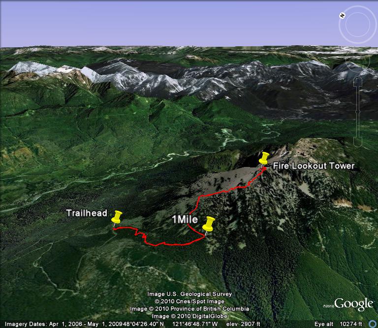
Mt Pilchuck Area

Trail up Mt Pilchuck to the Fire Lookout Tower
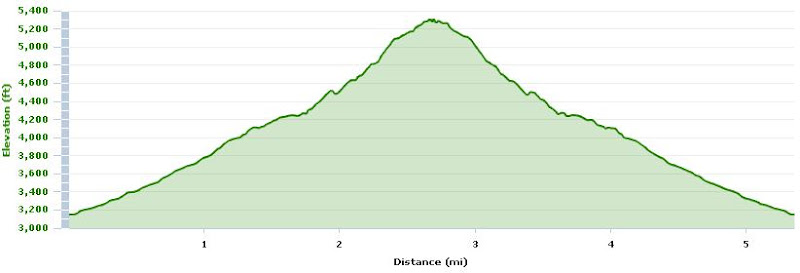
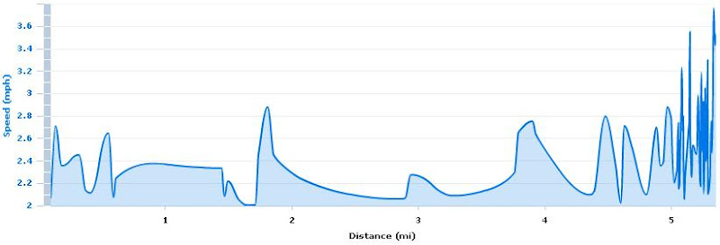
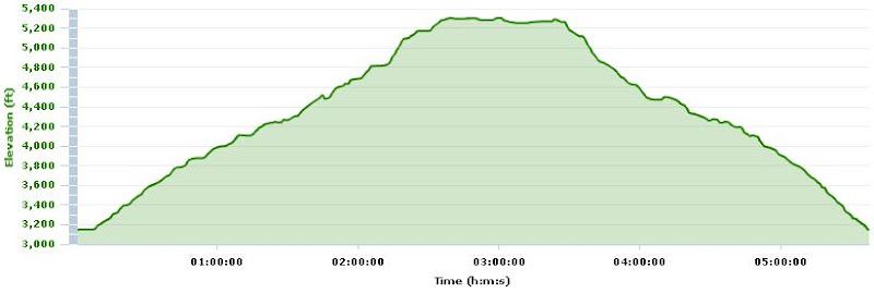
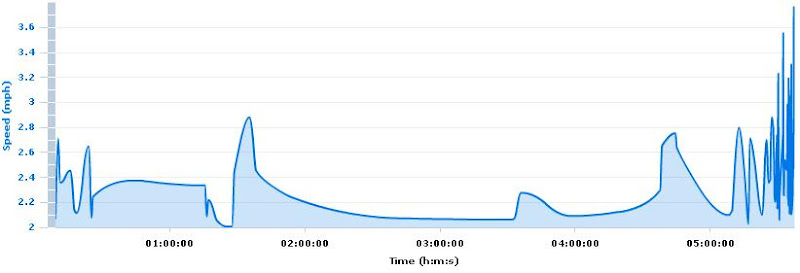
Stats
- Total Time: 5:37:43 (h:m:s)
- Distance: 5.36 mi
- Elevation Gain: 2,202 ft
- Average Overall Speed: 1.0 mph
- Average Moving Speed: 1.7 mph
- Maximum Elevation: 5,308 ft