Madonna Mountain 2-13-10
I took a long weekend to visit Cory down in San Luis Obispo (SLO) since he had Monday off for President's day. After quite the travel trip, I arrived in SLO just after midnight Friday night. And by travel trip I really mean the transportation I took. I drove to work and worked for half a day, before catching a Seattle bus to the Link Light rail to the airport. After landing in Burbank I took an airport shuttle bus to the 'train station'. I thought train station meant an actual building so I was surprised to find cement benches with a few overhangs. Luckily it was nice and sunny in California so I passed my 3 hours outside by reading. Finally the Amtrak train arrived. From the train I transferred to the Amtrak bus and finally arrived in SLO where Cory picked me up. It was fun getting to take so many forms of transportation, it was my urban adventure for the weekend.
Saturday was a beautiful day with sunshine and clear skies so we decided to go for a hike to Cerro San Luis, more commonly known as Madonna Mountain. There is a big M painted on the mountain that you can see from SLO. Cory and Scott had looked up a trail to take to reach the top of the mountain so we loaded up the car and took off. Unfortunately, the places we were trying to get to were barricaded with barbed wire and no parking on the streets. Finally we settled on going to the actual trail head. The mountain was very green which I really didn't think twice about, but Cory and Scott commented on it. When I was creating my trail map, I finally realized what they were talking about since the google satellite images show just how brown it usually is.
View Mount Madonna 2-13-10 in a larger map
As we started along the trail we passed a bell box. They had bells for mountain bikers to borrow so they could alert hikers along the trail, an interesting concept. I don't think I've encountered any bikers on the trails in Washington, just a couple horses. I noticed a patch of cacti off to the side, and then noticed a lot more. Not a usual sight for me on my hikes, but fun! There was a map along the trail that said the trail was closed at the M, but we had seen a boot beaten trail going up the mountain so we were hoping to find that. Well, we missed that trail but we found ourselves at the M. After taking in some views of SLO below us, we decided to continue past the M. Someone had already removed the barbed wire so people could continue. We took a quick break in the shade, just long enough for Cory to get some climbing in.
We finally emerged from the trees and were just below the top. We circled around and finally found our way to the top, with a great view of Bishop Peak (the hike we did during my last trip) and the surrounding area. On the way back to the car, Cory decided to pick a prickley pear from a cactus. After using the internet to look up how to cut it, we each tried a small piece. It reminded me a lot of watermelon, especially because of the seeds. We had a great hike followed by some delicious pizza, bread, queso, and rootbeer floats.

View Mount Madonna 2-13-10 in a larger map
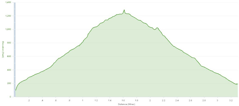
Stats
Way points are recorded on the Google map.
- Total Time: 2:09:07 (h:m:s)
- Distance: 3.3 mi
- Average Speed: 2.0 mph
- Maximum Speed: 5.12 mph
- Elevation Gain: 1320 ft
- Minimum Elevation: 62 ft
- Maximum Elevation: 1290 ft