McWay Falls 11-5-09
Our last adventure of the day was to a waterfall that falls into the ocean - yeah, it was beautiful. Driving south on route 1 we went to the Julia Pfeiffer Burns state park. A sign by the parking lot directed us, 0.25 miles to the McWay waterfall overlook. We crossed under route 1 through a tunnel and emerged to the ocean below. The scene was amazing: the waterfall, large rock formations, beach, and blue green water. The area along the coast really was quite the sight. At the end of the short trail are the remnants of an old house. After the woman died, she wanted the land turned into a park, the house torn down, and the beach closed off to the public to preserve McWay falls for future generations to enjoy. Some photographs on a sign explaining this story showed the view of the waterfall from the house, it was amazing! After a couple more pictures we walked back to the car and headed south to SLO, concluding our day of adventures in Big Sur.


View McWay Falls 11-5-09 in a larger map
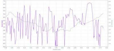
Stats
Way points are recorded on the Google map.
- Total Time: 00:23:27 (h:m:s)
- Time Breakdown: 23.9% Ascent, 23.6% Descent, 7.7% Flat, 44.8% Stopped (2 stops)
- Distance: 0.77 mi
- Distance Breakdown: 44.8% Ascent, 39.6% Descent, 15.6% Flat
- Moving Speed Average: 3.6 mph
- Average Speed Breakdown: 3.6 mph Ascent, 3.2 mph Descent, 3.6 mph Flat
- Maximum Speed: 6.7 mph
- Maximum Speed Breakdown: 6.7 mph Ascent, 6.3 mph Descent, 6.6 mph Flat
- Elevation Gain: 271 ft
- Vertical Speed Average: 20.9 ft/min Ascent, 18.8 ft/min Descent
- Vertical Speed Maximum: 177.6 ft/min Ascent, 102.8 ft/min Descent
- Grade Average: 14.2% Ascent, 11.9% Descent
- Grade Maximum: 19.6% Ascent, 39.5% Descent
- Temperature Average: 65.3 deg F